Benson Relief Road
A scheme to provide an alternative route from the A4074 and B4009 to the north of Benson village.
About the improvements
The Benson Relief Road will provide the new housing developments north of Benson village with direct access to the A4074 (Elms Bridge Roundabout) and B4009 (west of Braze Lane).
Why we are investing here
The area will see significant growth in the coming years, and investment is needed so that the transport network can meet the demands that will be placed upon it in the future.
The scheme will offer the following benefits:
- Help to unlock development sites to the north of Benson village along the new route, and support the delivery of around 600 new homes
- Reduce congestion through Benson village and an alternative route from the A4074 and B4009
- Capacity improvements at the A4074 / Church Road junction.
- Provide high-quality pedestrian/cycle infrastructure
- Improve air quality.
What you can expect
Phase 2 works
The archaeological works on the flood compensation area (FCA) are complete. Further construction work for the FCA is underway, including landscaping and planting.
We are now progressing into phase 2, the main civil works of the road. Construction is expected to be complete by the end of October.
The details of Phase 2 are:
| Works start date | Mid-February 2024 |
|---|---|
| Working times | Monday to Friday, 7.30am to 6pm (subject to weather) |
| Duration | Approximately 36 to 38 weeks (subject to weather) |
Some tree and vegetation clearance will need to be undertaken across 3-4 days in mid-March. The purpose of these works is to prepare the site for the main construction work and ensure the safety and functionality of the road network.
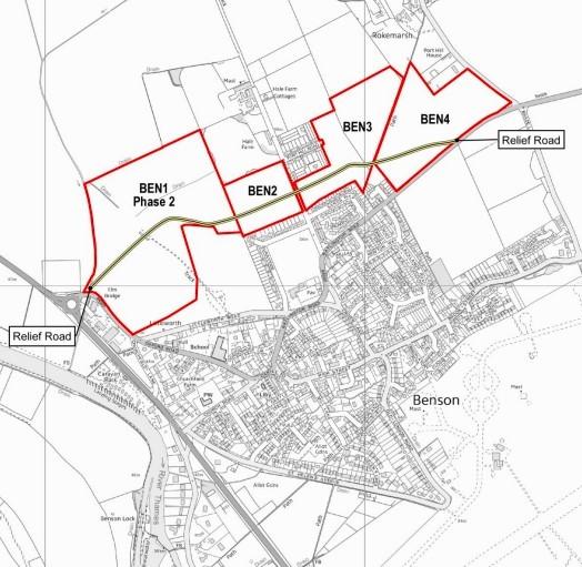
The Benson Relief Road is being constructed in sections by several housing developers and Oxfordshire County Council. The council only provides the southwesterly section (approximately 250m length) of the relief road.
The image shows the four housing developments and the Benson Relief Road route.
Timescales
| Activity | Work Commence | Duration |
| Flood compensation area and archaeology work | November 2023 | Approx 3 months (weather dependant) |
| Construction of the southwesterly section of the Benson Relief Rd, delivered by the council | January 2024 | Approx 10 months (weather dependant) |
| Council section of road open to traffic | Late summer 2024 | |
| The entire Benson Relief Road open to traffic | Expected 2026 (subject to developer timescales) |
Minimising the impact
We will be working hard to minimise disruption as much as possible. Any temporary traffic management measures employed will be continually monitored throughout each day of construction, so that we can respond quickly to traffic conditions as they happen.
All construction traffic will access the site via the B4009 Oxford Road, via the existing development construction access.
Noise and dust will be limited as much as possible, but there will be periods when noise is unavoidable. The works will be carried out between the hours of 7.30am and 6pm, Monday to Friday. Any working outside of these times will be notified to residents in advance.
Road closures and diversions on the B4009 Oxford Road are expected whilst we realign and reconstruct our section of the road. This is anticipated to take place in early summer 2024. Further details will be provided nearer the time regarding diversion routes, working times and durations.
Traffic management arrangements are also available by visiting https://one.network
How it is being funded
The scheme is being funded through a combination of Growth Deal funding and Section 106 contributions from developers.
Next steps
Construction will take place in two parts - the first being the construction of the flood compensation area (FCA) and archaeology works, therefore ensuring flood capacity is provided at all times before the relief road is constructed. These works commenced in October 2023.
The second part will involve the main construction work of the relief road. This started in February 2024.
To facilitate the tree and vegetation clearance, a lane will be closed on the B4009 Oxford Road, around Elm Bridge, for 3-4 days in mid-March. There will be temporary traffic lights in operation between 9.30am and 3.30pm.
Residents and commuters are kindly requested to exercise caution while passing through the road works and adhere to any temporary traffic control measures that may be in place.
Contact us
If you would like to know more, you can contact us by email: bensonrrproject@oxfordshire.gov.uk
More information
Why is the scheme needed?
Oxfordshire needs a modern, efficient, reliable, affordable, and sustainable transport system. The South Oxfordshire district will see significant growth in housing. Investment is needed now so that the transport network can meet the demands that will be placed upon it in the future.
The Benson Relief Road will not only provide direct benefits to the residents of the Benson housing development and the wider village but also wider benefits such as:
- improved air quality in Benson by reducing traffic congestion.
- provide essential relief to Benson village and surrounding road junctions by creating an alternative route.
- Improve the pedestrian and cycle environment, by providing high-quality pedestrian/cycle facilities.
What improvements works are planned to take place, including those for public transport and walking and cycling?
Known as the Benson Relief Road, the new road will run between the B4009 Oxford Road, and B4009 The Sands. It will also provide the Benson housing development with direct access onto the B4009 both north and south of Benson village.
The Benson Relief Road scheme has been split into four sections. The road sections through the housing development sites known as BEN1, BEN2, BEN3 and BEN4 are being funded and delivered by various housing developers. The link between BEN1 and B4009 Oxford Road (approximately 250m only) will be constructed by Oxfordshire County Council, through our contractor, Milestone Infrastructure.
Once the road is fully completed and open to all traffic, bus operators will provide more details about any potential services using the route.
Is planning consent granted?
Yes, planning consent was granted in January 2022.
What about the archaeology?
A planning condition ensures that before any construction works can commence, a programme of archaeology ‘trace, strip and map’ will be undertaken, ensuring that any archaeological finds are recorded. These results will be made available upon completion of these works.
The road is being built in a floodplain, what does this mean?
The relief road is being built within the flood plain, and as such, a flood compensation area (FCA) is being provided, to offset any loss in flood capacity.
The FCA is a large area of land away from the relief road, which provides a storage facility in the event of a flood to compensate for the land taken to build the road. The area will be fenced and landscaped and wildlife will be encouraged through the design of landscaping.
Will it increase the likelihood of flooding?
No. The road has been designed and will be built, ensuring that both sides of the road are able to accommodate flooding. The construction of the FCA is such that it has an allowance for the capacity of any flood water. It will, however, be managed in the way in which it floods.
Will there be landscaping planted as part of the new relief road?
Yes, semi-mature trees and shrubs will be planted to encourage biodiversity and wildlife.
When will construction work commence?
Construction will take place in two parts - the first being the construction of the flood compensation area (FCA) and archaeology works, therefore ensuring flood capacity is provided at all times before the relief road is constructed. These works commenced in October 2023.
The second part will involve the main construction works of the relief road. This is due to commence in early 2024.
How long will construction take?
Works to the FCA and archaeology activity will take approximately 12 weeks, depending on the weather.
Works to the relief road will take approximately 10 months, depending on the weather.
Will there be any road closures during construction?
Yes, there will be road closures and diversions on the B4009 Oxford Road whilst we realign and reconstruct this section of the road. This is likely to be around summer 2024. Further details will be provided nearer the time in terms of diversion routes, working times and durations.
Traffic management arrangements are also available by visiting https://one.network.https://one.network
How much will it cost?
The work on Benson Relief Road will cost approximately £6.9m
Where is the money coming from to pay for it?
The scheme is being financed through Growth Deal funding and Section 106 contributions from developers.
What is the impact on traffic going to be?
The aim of the work is ultimately to reduce traffic through the village of Benson, making travelling between Wallingford and Watlington better.
We will be working hard to minimise disruption as much as possible. Any temporary traffic management measures employed will be continually monitored throughout each day of construction, so that we can respond quickly to traffic conditions as they happen.
How will construction traffic access the site?
All construction traffic will access the site via the B4009 Oxford Road, via the existing development construction access.
What is the width of the proposed cycleway and footway?
The scheme will provide segregated footways of 2m wide and cycleways of 1.5m wide along the entire relief road route.
What will be the proposed speed limit of the Relief road?
The proposed speed limit will be 30mph.
Will the road be street-lit?
Yes, the road will have street lighting. The lanterns will be “dark skies compliant” therefore reducing upwards light spill and pollution, and will use LED bulbs for reduced running and maintenance costs.
Will the relief road take HGV traffic away from Benson village?
Yes, the idea is that the relief road will, when all sections are complete, provide a sign-posted route for HGV traffic to reduce traffic through Benson village.
Upon completion of all sections of the relief road within the Benson development corridor, a continuous road link will be in place. Therefore, a traffic regulation order for a weight restriction of 7.5t will be placed upon entry to the surrounding roads through the village, along with replacement road signage directing traffic to use the new relief road.
What about satellite navigation?
Upon completion of the works, it is normal practice for Oxfordshire County Council to notify the main sat nav providers, such as Google, Waze and TomTom about the road improvements.
Will there be noise and dust during construction?
Noise and dust will be limited as much as possible but there will be periods when noise is unavoidable. The works will be carried out between the hours of 7.30am and 6pm, Monday to Friday. Any working outside of these times will be notified to residents in advance.
What will the emergency services do?
All emergency services have been informed of the roadworks so that they can choose the most appropriate route. Emergency services are allowed to pass through road closures and are well-practiced in finding the best ways to get to their destination in all circumstances. We do not anticipate any disruption to emergency services.
What will happen to the construction access upon completion of the works?
The access for construction vehicles will be removed upon completion of the road and landscaping will be reinstated to the area to match the adjoining greenspace, including footpaths and planting.
Will the contractor be using local subcontractors?
Yes, Oxfordshire County Council openly promotes the use of local suppliers and supply chain for all works.
Will the contractor employ apprentices?
Yes, Oxfordshire County Council ensures that all supply chain contractors have a minimum level of apprentices within each contract, to both encourage and support apprenticeships in accordance with Government guidance.
I walk my dogs in this open space where the road is to be built, will I be able to continue to do so whilst works are ongoing?
Yes, however, whilst works are ongoing, there will be restrictions in the area for safety reasons. We will endeavour to provide safe crossing points between the open spaces at all times.
How is OCC considering the environmental impact of the planned improvements and will any trees be removed?
An Environmental Impact Assessment (EIA) has been undertaken at the site, which assesses the impact of construction on the environment, wildlife, and ecology; as a result, various mitigation and protection works will be installed in accordance with the applicable legislation.
During construction, all site offices and plant will, where possible, use biodiesel, solar energy, and recycled materials to reduce the works' environmental impact
No trees are being removed as part of the construction of the county council’s section of the road and a scheme of planting semi-mature trees along the new road is planned for further enhancement to the area.
The proposed relief road will incorporate a mammal tunnel within its construction, as well as an otter tunnel that will be installed at Elm Bridge, to help ensure mammals can maintain their natural, safe routes of travel.
How can I ask a question, request further details, or make a compliment /complaint/comment?
You can email the project team at bensonrrproject@oxfordshire.gov.uk or write to: Oxfordshire County Council, County Hall, New Road, Oxford, OX1 1ND.
You can also sign up for regular news and alerts from Oxfordshire County Council’s Travel Bulletin.